Introduction to GPR Surveying in London
Ground Penetrating Radar (GPR) is one of the most advanced tools available for subsurface investigation, and in a historic, complex city like London, its value cannot be overstated. GPR surveyors london are equipped with cutting-edge technology and in-depth local knowledge that enables them to detect features, utilities, and anomalies that traditional surveyors or general contractors might overlook. The depth and accuracy of information GPR provides help protect infrastructure, reduce project risks, and ensure compliance with planning regulations.
Understanding How GPR Works
GPR operates by sending high-frequency radio waves into the ground through a transmitter. When these waves encounter buried objects or changes in material composition, they reflect back to a receiver. The surveyor then analyzes these reflections to interpret the location, depth, and shape of underground features. The result is a highly detailed image of what lies beneath the surface—without excavation or physical disturbance. This non-invasive method is ideal for urban environments like London, where history and modern infrastructure are tightly interwoven.
Unique Challenges Beneath London’s Surface
London’s underground environment is a patchwork of centuries-old utilities, tunnels, basements, and foundations. Many of these are poorly documented or undocumented altogether. Victorian-era brickwork, disused pipes, war shelters, and even archaeological artifacts lie beneath modern pavements. In such conditions, traditional surveying techniques, which often rely on maps and visual clues, fall short. GPR surveyors, by contrast, can cut through the historical clutter to reveal hidden risks and opportunities.
What GPR Surveyors Can Detect That Others Might Miss
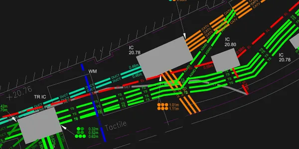
Subsurface Utilities Not Listed on Records
Utility maps are often outdated or inaccurate. GPR surveyors in London can identify gas lines, water mains, telecom conduits, and electrical cables that are not recorded in local authority databases. This detection capability is essential to prevent accidental damage, costly project delays, or hazardous incidents during excavation.
Reinforced Concrete Features
GPR is exceptionally good at locating and mapping the internal structure of concrete, including rebar, post-tension cables, and embedded conduits. For engineers and contractors working on basement conversions, commercial buildings, or infrastructure projects, knowing where to drill or cut without damaging reinforcement is critical.
Underground Voids and Cavities
Unseen voids such as collapsed tunnels, sinkholes, or old brick sewers pose significant safety risks. GPR can detect these hidden cavities, which might otherwise remain undetected until a collapse occurs. Identifying voids in advance ensures safer excavation and construction planning.
Buried Foundations and Footings
Many areas of London are built on the ruins of older buildings. GPR can detect old stone or concrete footings, foundations, and slab remnants. This is particularly useful when redeveloping brownfield sites or extending existing structures, as it helps engineers avoid interference or structural surprises.
Historical Artifacts and Archaeological Features
In areas of archaeological sensitivity, GPR provides a non-invasive method to identify buried features such as walls, ditches, pottery fragments, and ancient roads. While not a substitute for a full archaeological survey, GPR offers early warning signs that trigger further investigation, helping developers comply with heritage regulations.
Water Ingress and Moisture Pockets
GPR can detect changes in material density and dielectric properties, which often indicate moisture. In areas prone to flooding or with underground water issues, GPR can locate water ingress points, leaking pipes, or subsurface moisture—helping to plan effective drainage and waterproofing solutions.
Changes in Soil Composition
Detecting changes in subsurface material—such as shifting from clay to gravel—can be crucial in assessing ground stability, foundation design, or borehole placement. GPR allows surveyors to map these transitions with high precision, even when other methods show limited sensitivity.
Mapping Shallow Tunnels and Subways
London’s labyrinth of subways and pedestrian tunnels, particularly in central zones, pose unique engineering challenges. GPR helps identify the location and depth of such infrastructure, even if they are unrecorded, ensuring that development work proceeds without interrupting public transportation or undermining safety.
The Advantage of Trained GPR Professionals in London
Professional GPR surveyors combine technical expertise with real-world experience. In London, this means not just knowing how to read radar data, but understanding local construction practices, historical layering, and city-specific risks. They can distinguish between natural soil features and man-made utilities, and they know when a faint signal might represent something critical. This interpretive skill is where true value lies—turning radar echoes into actionable insights.
GPR in Different Project Phases
During Site Feasibility
Before committing to construction plans, developers need a clear picture of what lies beneath. GPR surveys during the feasibility phase reveal any major obstacles that might require design changes or legal considerations, such as protected utilities or heritage elements.
During Design and Engineering
Designers use GPR data to fine-tune plans around existing structures and services. Avoiding conflicts with subsurface utilities ensures that planning approvals are secured faster and that later-stage construction proceeds smoothly.
During Construction
On active sites, GPR helps monitor changes, check for newly formed voids, and support safe excavation. Engineers may also use it for slab scanning before coring or anchoring into concrete.
Post-Construction Validation
After utility rerouting or underground installations, GPR provides accurate as-built documentation. This ensures future maintenance teams and city officials have updated records of buried infrastructure.
Regulatory and Legal Implications
Failing to detect underground risks can lead to fines, liability claims, or project shutdowns. London has strict health and safety regulations, and utility companies enforce rigid access rules. Engaging qualified GPR surveyors who follow PAS 128 standards (UK specification for underground utility detection) demonstrates due diligence and protects against legal exposure.
Choosing the Right GPR Surveyor in London
The best GPR surveyors offer more than just scanning—they provide:
-
Experience with London-specific challenges
-
High-frequency and deep-penetrating radar systems
-
PAS 128-compliant methodologies
-
Clear reporting with CAD/BIM outputs
-
Flexible service timing to match project milestones
-
Transparent pricing and follow-up support
By comparing qualifications, tools, and case studies, clients can choose surveyors who consistently deliver high-quality results under pressure.
Future-Proofing Projects with GPR Data
Accurate GPR surveys don’t just help during current projects—they create a valuable record for the future. As London continues to evolve, redevelopment and infrastructure upgrades will rely on today’s data to reduce costs and preserve safety. Clients who invest in detailed surveys now will avoid major headaches later.
Final Thoughts
In a city where what’s buried is often more complicated than what’s visible, expert GPR surveyors play a crucial role. They uncover risks, reveal opportunities, and provide clarity in environments filled with uncertainty. While others might miss the subtle signals of a disused cable duct, a buried wall, or a dangerous void, professional GPR surveyors in London have the tools and insight to catch them all. When safety, accuracy, and compliance are on the line, working with skilled GPR specialists isn’t just smart—it’s essential.